Location of Kīlauea on Hawaiʻi island
← ホームへ戻る

キラウエア火山ハワイ島を形作る世界で最も活発な盾状火山

ハワイ諸島の南東端、ハワイ島の海岸線に位置するキラウエア火山は、地球上で最も活動的な火山の一つとして知られています。この火山は、粘性の低い溶岩が幾層にも積み重なって緩やかな傾斜を持つ「盾状火山(たてじょうかざん)」であり、ホットスポットと呼ばれる地球内部の熱い上昇流によって形成されました。

約21万年から28万年前に誕生したとされるこの火山は、約10万年前に海面上に姿を現しました。現在も絶え間なく活動を続けており、ハワイ島を構成する5つの火山の中でも際立って高い活動頻度を誇っています。
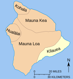
Location of Kīlauea on Hawaiʻi island

主要な事実(Key Facts)

  • 山体形式: 盾状火山およびホットスポット火山
  • 最高地点: 標高 1,247メートル
  • 推定年齢: 21万年〜28万年前(海面上への出現は約10万年前)
  • 最新の活動: 2024年12月から継続的な噴火が発生し、2026年にかけて断続的な溶岩噴水が観測されている
  • 最大の特徴: 非常に頻繁な噴火活動と、広大な溶岩原の形成

地質学的構造と噴火のメカニズム

キラウエアの活動は、主に山頂のカルデラ内にあるハレマウマウというピットクレーター(陥没穴)と、山頂から東へ伸びる「東リフトゾーン」という割れ目帯で展開されます。溶岩はこれらの経路を通じて地表に現れ、緩やかに流下して新たな土地を形成します。
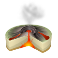
Scheme of a Hawaiian eruption

噴火の形態は、穏やかに溶岩が流れ出す「流出型」が主流ですが、稀に激しい爆発を伴うことがあります。例えば、1790年に発生した爆発的噴火では400人以上の犠牲者が出ており、これは米国領土内で発生した火山災害として最悪の規模となりました。
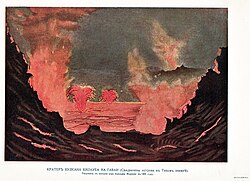
Painting of the 1891 eruption

噴火の多様性と観測データ

過去200年の記録を見ると、キラウエアは極めて多様な活動パターンを示しています。1823年に最初の文書記録が残されて以来、山頂やリフトゾーンで数多くの噴火が繰り返されてきました。
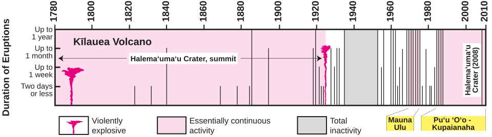
Graph summarizing the eruptions of Kïlauea during the past 200 years. The Pu‘u ‘Ö‘ö- Kupaianaha eruption has continued into the 21st century. Information is sketchy for eruptions before 1823, when the first missionaries arrived on the Island of Hawai‘i. The total duration of eruptive activity in a given year, shown by the length of the vertical bar, may be for a single eruption or a combination of several separate eruptions.

また、火山爆発指数(VEI)に基づいた分析では、VEI 0から1の小規模な噴火が大多数を占めていますが、稀にVEI 4に達する大規模な活動も記録されています。

近現代の主要な噴火エピソード

長期化したプウオオ噴火(1983年〜2018年)

現代において最も特筆すべきは、1983年1月3日から2018年まで続いた長期噴火です。これは地球上の記録の中でも極めて長い期間の活動であり、東リフトゾーンのプウオオ円錐丘から大量の溶岩が供給され、123.2平方キロメートルに及ぶ土地が塗り替えられました。
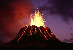
Puʻu ʻŌʻō at dusk, June 1983

2018年の大規模崩壊と変動

2018年5月、ハレマウマウの溶岩湖が低下し、地下水との反応による水蒸気爆発の危険性が高まりました。その後、高度約9,000メートル(30,000フィート)まで達する巨大な灰柱を伴う爆発的噴火が発生し、山頂付近では大規模な陥没と地盤崩壊が起こりました。
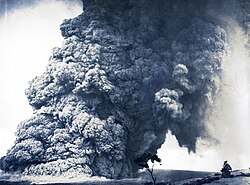
An explosive eruption column from Halema‘uma‘u crater on May 18, 1924. One of many in May 11–27, 1924.

同時に、下部東リフトゾーンでは新たな割れ目から溶岩が噴出し、住宅地であるレイラニ・エステーツなどの地域に甚大な被害をもたらしました。
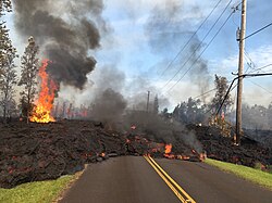
Lava from a fissure slowly advanced to the northeast on Hoʻokupu Street in Leilani Estates subdivision (May 5, 2018)

2020年代の最新活動

2020年以降、ハレマウマウでは再び溶岩湖の形成や断続的な噴火が繰り返されています。2024年9月には人里離れたナパウクレーター付近で噴火が発生し、さらに2024年12月からは山頂での活動が再開しました。
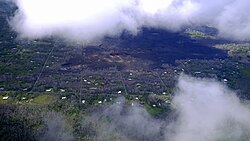
Kilauea Volcano Fissure 8 captured on May 3rd, 2019

2025年から2026年にかけては、高さ460メートルに達する巨大な溶岩噴水(エピソード35)や、秒速760〜920立方ヤードという極めて高い溶岩流出率を記録する激しい活動が観測されています。
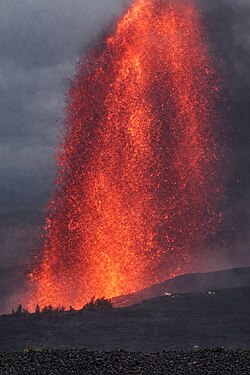
Explosive strombolian lava fountain during Episode 42 on February 15, 2026

環境と生態系への影響

火山活動は破壊をもたらす一方で、新たな生命の基盤も作り出します。溶岩で覆われた不毛の地に、オヒアなどの先駆植物が根を張り、次第に豊かな生態系が回復していく様子が観察されています。
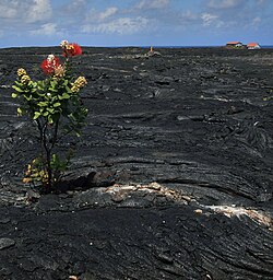
ʻŌhiʻa (Metrosideros polymorpha) growing on a barren lava field dating from 1986, formerly the village of Kalapana, Hawaii. The myrtle in this picture, taken in 2009, may have since been covered over—fresh flows in 2010 partially re-covered the area.

また、火山の斜面にはアマキヒなどの固有種を含む多様な鳥類が生息しており、過酷な環境に適応した独自の自然環境が維持されています。
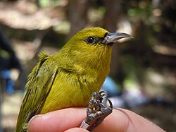
The ʻamakihi (Chlorodrepanis virens) is one of the many birds that live on the volcano's flanks.

科学的調査とモニタリング

ハワイ火山観測所(HVO)は、GPSデータや地震計を用いて、地盤の変形やマグマの移動を24時間体制で監視しています。こうした研究には学生などの若手研究者も参加しており、次世代への技術継承が行われています。
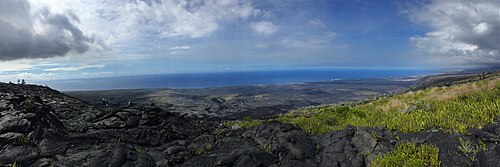
Students collecting GPS data for the USGS in Kīlauea's eastern rift zone in 2015

山頂の景観は噴火のたびに劇的に変化します。例えば、2008年時点ではガス噴煙が目立っていたハレマウマウも、2018年の崩壊を経て、現在は深く陥没したクレーターへと姿を変えています。
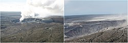
Two views of Halemaʻumaʻu from roughly the same vantage point. At left is the view from 2008, with a distinct gas plume from the Overlook vent, the location of what would become a long-lived lava lake. At right is a view of Halemaʻumaʻu after the eruptive events of 2018, showing the collapsed crater.

その他の観測風景

火山活動の合間には、クレーター内に水が溜まって湖が形成されるなど、ダイナミックな変化が起こります。また、冬の夕暮れ時に赤く光る溶岩や、噴煙に架かる虹など、幻想的な光景が見られることもあります。
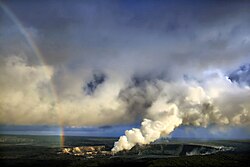
Rainbow and volcanic ash with sulfur dioxide emissions from Halemaʻumaʻu (April 2008)
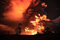
View of the eruption from outside Kaluapele, on December 20, 2020
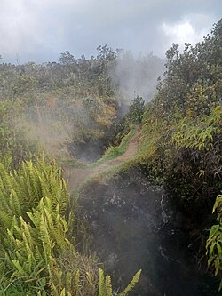
Steam venting from fissures inside Kaluapele, October 2022
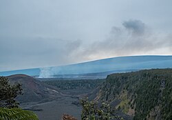
View from the edge of Kilauea Iki: across Kaluapele, Halemaʻumaʻu is emitting fume on the left side of Kaluapele, while Mauna Loa towers above in the background (March 2013)
Glowing lava at sunset, seen from near Volcano House, October 2022

かつて1969年のマウナウル噴火では、高さ300メートルに達する溶岩噴水が記録されており、キラウエアが持つ圧倒的なエネルギーを象徴しています。
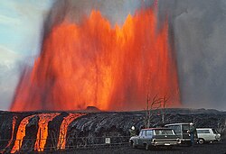
The Mauna Ulu eruption of 1969 generated a 300-metre (1,000 ft)-high lava fountain

キラウエア火山 概要まとめ

キラウエア火山の基本データ
項目 詳細内容
火山タイプ 盾状火山 / ホットスポット火山
最高標高 1,247 m
形成時期 約21万〜28万年前
主な噴火地点 ハレマウマウ(山頂)、東リフトゾーン
特筆すべき噴火 1790年(最大被害)、1983-2018年(最長期間)
最新の状況 2024年12月〜2026年(断続的な噴火活動)

Frequently Asked Questions

キラウエア火山はどのような種類の火山ですか?

粘性の低い玄武岩質の溶岩が広範囲に流れ出し、盾のような緩やかな傾斜を持つ「盾状火山」です。地球内部のホットスポットの上に位置しているため、プレートの移動に関わらず長期的に活動を続けています。

過去に最も被害が大きかった噴火はいつですか?

1790年に発生した爆発的噴火です。この際、400人以上の人々が犠牲となり、米国領土内で発生した火山噴火としては史上最悪の死者数を記録しました。

2018年の噴火では何が起こりましたか?

山頂のハレマウマウで激しい爆発と地盤崩壊が起こると同時に、下部東リフトゾーンで新たな割れ目噴火が発生しました。これにより多くの住宅が溶岩に飲み込まれ、地形が大きく書き換えられました。

現在も噴火は続いていますか?

はい。2024年12月から新たな噴火が始まっており、2025年から2026年にかけても、高さ数百メートルに達する溶岩噴水や溶岩流が断続的に観測されています。

火山活動による環境への影響は?

短期的には森林や集落の破壊をもたらしますが、長期的には新しい土地を創出します。溶岩原にはオヒアなどの植物が再び根付き、独自の生態系が再生していくサイクルが繰り返されています。

References

  1. "4088". NGS Data Sheet. , , .
  2. "Kilauea Prominence". Peakbagger.com. Retrieved May 5, 2018.
  3. "Kīlauea Volcano Erupts in Explosive and Effusive Cycles". – . January 19, 2012. Archived from the original on June 18, 2020. Retrieved January 15, 2019.
  4. "Into thin air:Lava flows claim Hawaii's largest lake in a matter of hours". Hawaii News Now. June 5, 2018.
  5. "Kapoho Beach Lots, Vacationland destroyed by lava". Hawaii Tribune-Herald. June 5, 2018.
  6. "Preliminary summary of Kilauea Volcano's 2018 lower East Rift Zone eruption and summit collapse" (PDF). US Geological Survey. Retrieved December 5, 2018.
  7. "Hawaii volcano erupts from summit, shooting plume of ash". CBS News. May 18, 2018.
  8. Swanson, Donald A. (October 1, 2008). "Hawaiian oral tradition describes 400 years of volcanic activity at Kīlauea". Journal of Volcanology and Geothermal Research. Volcanoes and Human History. 176 (3): 427–431. :2008JVGR..176..427S. :10.1016/j.jvolgeores.2008.01.033.  0377-0273 – via Elsevier Science Direct.
  9. Israel, Brett (December 6, 2011). "Kilauea Volcano's Deadliest Eruption Revealed". Live Science. Retrieved May 11, 2018.
  10. Swanson, Donald A.; Rose, Timothy R.; Fiske, Richard S.; McGeehin, John P. (February 15, 2012). "Keanakākoʻi Tephra produced by 300years of explosive eruptions following collapse of Kīlauea's caldera in about 1500CE". Journal of Volcanology and Geothermal Research. 215–216: 8–25. :10.1016/j.jvolgeores.2011.11.009.  0377-0273.

📸 フォトギャラリー

Location of Kīlauea on Hawaiʻi island
Graph summarizing the eruptions of Kïlauea during the past 200 years. The Pu‘u ‘Ö‘ö- Kupaianaha eruption has continued into the 21st century. Information is sketchy for eruptions before 1823, when the first missionaries arrived on the Island of Hawai‘i. The total duration of eruptive activity in a given year, shown by the length of the vertical bar, may be for a single eruption or a combination of several separate eruptions.
Rainbow and volcanic ash with sulfur dioxide emissions from Halemaʻumaʻu (April 2008)
Painting of the 1891 eruption
An explosive eruption column from Halema‘uma‘u crater on May 18, 1924. One of many in May 11–27, 1924.
The Mauna Ulu eruption of 1969 generated a 300-metre (1,000 ft)-high lava fountain
Puʻu ʻŌʻō at dusk, June 1983
Lava from a fissure slowly advanced to the northeast on Hoʻokupu Street in Leilani Estates subdivision (May 5, 2018)
Kilauea Volcano Fissure 8 captured on May 3rd, 2019
Two views of Halemaʻumaʻu from roughly the same vantage point. At left is the view from 2008, with a distinct gas plume from the Overlook vent, the location of what would become a long-lived lava lake. At right is a view of Halemaʻumaʻu after the eruptive events of 2018, showing the collapsed crater.
View of the eruption from outside Kaluapele, on December 20, 2020
Explosive strombolian lava fountain during Episode 42 on February 15, 2026
ʻŌhiʻa (Metrosideros polymorpha) growing on a barren lava field dating from 1986, formerly the village of Kalapana, Hawaii. The myrtle in this picture, taken in 2009, may have since been covered over—fresh flows in 2010 partially re-covered the area.
The ʻamakihi (Chlorodrepanis virens) is one of the many birds that live on the volcano's flanks.
Students collecting GPS data for the USGS in Kīlauea's eastern rift zone in 2015
Steam venting from fissures inside Kaluapele, October 2022
View from the edge of Kilauea Iki: across Kaluapele, Halemaʻumaʻu is emitting fume on the left side of Kaluapele, while Mauna Loa towers above in the background (March 2013)
Glowing lava at sunset, seen from near Volcano House, October 2022
Scheme of a Hawaiian eruption