インドネシアの小スンダ列島、スンバワ島に位置するタンボラ山(別名:トンボロ)は、世界で最も破壊的な噴火を起こしたことで知られる活火山です。この山は、プレートの沈み込み帯という地質学的な不安定な領域に形成された成層火山であり、その活動は単なる局所的な災害に留まらず、地球全体の気候を激変させるほどの規模を持っていました。
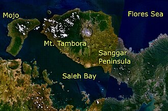
主要な事実(Key Facts)
- 最大級の噴火: 1815年の噴火は記録史上最大であり、火山爆発指数(VEI)は「7」に達した。
- 気候への影響: 大量に放出された硫酸エアロゾルにより、翌1816年は「夏のない年」と呼ばれた。
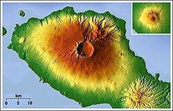
- 地形の激変: 噴火前は約4,300mの標高を誇っていたが、噴火後は約2,850mまで低下した。
- 甚大な被害: 直接的な死者は少なくとも7万1,000人に上ると推定されている。
- 現在の状態: 現在も活火山であり、直近では1967年に非爆発的な噴火が記録されている。
地質学的背景と形成プロセス
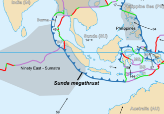
タンボラ山は、オーストラリアプレートがスンダプレートの下に年間約7.8センチメートルの速度で沈み込むことで形成されました。この火山活動の始まりは、約4万3,000年前から5万7,000年前まで遡ると考えられています。
山体の形成過程では、地下に巨大なマグマ溜まりが存在し、それが排出されることで地形が変化しました。約2万5,000年前にはサレ湾という海盆が出現し、同時にモジョ小島が形成されるなど、ダイナミックな地殻変動が繰り返されてきました。
1815年の大噴火:その衝撃とメカニズム
数世紀にわたる休止期間中、地下のマグマ溜まりでは水分を含むマグマが徐々に冷却され、極めて高い圧力が蓄積されていました。1812年に前兆活動が始まり、1815年4月にそのエネルギーが爆発的に解放されました。
この噴火の規模は凄まじく、放出されたテフラ(火山砕屑物)の総量は最大1,800立方キロメートルに達しました。爆発音は2,600km離れたスマトラ島や、さらにはタイ、ラオスにまで届いたと伝えられています。また、噴火に伴う火砕流は山頂から約20kmまで広がり、巨大なカルデラ(噴火後の陥没地形)を形成しました。
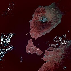
噴火による灰の降下は広範囲に及び、ボルネオ島やスラウェシ島などの周辺諸島にまで達しました。この現象は、当時の地域社会に壊滅的な打撃を与えただけでなく、成層圏に大量の硫酸エアロゾルを送り込みました。
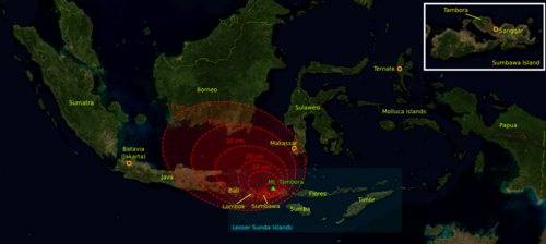
世界的な気候変動「夏のない年」
成層圏に広がった火山灰とガスは太陽光を遮断し、北半球を中心に気温を低下させました。その結果、1816年は「夏のない年」となり、北米や欧州では農作物の不作と家畜の死が相次ぎ、19世紀最悪の飢饉を引き起こしました。
![Sulfate concentration in ice core from Central Greenland, dated by counting oxygen isotope seasonal variations. There is an unknown eruption around the 1810s.[51]](/images/1d/69/1d69d83b5914e8240b4e40cb0d68e8aebf80df6c5da7f86471d800e4f1f1c7f7.png)
噴火後の地形と現在の状況
大噴火の結果、タンボラ山の山頂部は消失し、直径6〜7km、深さ600〜700mの巨大なカルデラが残されました。かつての最高峰としての威容は失われましたが、現在はその独特な地形が研究対象となっています。
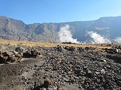
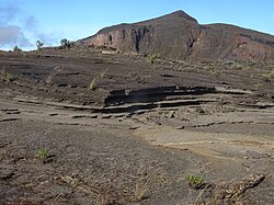
カルデラ内部や周辺では、その後も小規模な溶岩ドームの形成や溶岩流が確認されており、火山としての活動は完全に停止したわけではありません。1967年には穏やかな噴火が記録され、2011年にも地震や水蒸気の放出に伴い警戒レベルが引き上げられるなど、現在も厳重な監視下にあります。
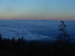
また、山頂付近からは遠く165km離れたリンジャニ山を望むことができ、この地域の火山弧の壮大さを物語っています。
主要火山噴火の比較まとめ
タンボラ山の噴火がどれほど異例であったか、他の歴史的な噴火事例と比較します。
| 火山名 | 場所 | 噴火年 | VEI | 北半球夏季気温への影響 | 推定死者数 |
|---|---|---|---|---|---|
| タンボラ山 | インドネシア | 1815 | 7 | −0.5 °C | 71,000人以上 |
| クラカタウ | インドネシア | 1883 | 6 | −0.3 °C | 36,600人 |
| ピナトゥボ山 | フィリピン | 1991 | 6 | −0.5 °C | 1,202人 |
| セント・ヘレンズ山 | アメリカ | 1980 | 5 | なし | 57人 |
Frequently Asked Questions
タンボラ山の1815年の噴火がなぜ「史上最大」と言われるのですか?
放出された火山物質の量が極めて多く、火山爆発指数(VEI)で最高レベルに近い「7」を記録したためです。また、その影響が局所的な被害に留まらず、地球全体の気温を低下させ、世界的な飢饉を引き起こした点でも類を見ない規模でした。
「夏のない年」とは具体的にどのような現象でしたか?
噴火によって成層圏に放出された大量の硫酸エアロゾルが太陽光を反射し、地表に届く日射量が減少したことで起こりました。これにより、1816年の北半球では夏になっても気温が上がらず、異常低温による深刻な農作物の不作が発生しました。
現在のタンボラ山は安全ですか?
タンボラ山は現在も活火山に分類されています。1967年に非爆発的な噴火が記録されており、2011年にも活動の活発化が見られたため、インドネシア当局によって継続的にモニタリングが行われています。
噴火によって山の高さはどれくらい変わりましたか?
噴火前は標高約4,300メートルあり、インドネシア群島でも有数の高さを誇っていましたが、大噴火による山体崩壊とカルデラの形成により、最高地点は約2,850メートルまで減少しました。
References
- "Tambora". . . Retrieved 24 June 2021.
- "Gunung Tambora". Peakbagger. Archived from the original on 19 March 2007. Retrieved 21 December 2024.
- "Gunung Tambora". Peakbagger. Archived from the original on 19 March 2007. Retrieved 2 August 2018.
- "Mount Tambora Volcano, Sumbawa Island, Indonesia". www.earthobservatory.nasa.gov. Nasa. 19 July 2009. Retrieved 1 November 2025.
- "Mount Tambora". Mount Tambora. Archived from the original on 30 September 2021. Retrieved 4 March 2021.
- Foden, J. (1986). "The petrology of Tambora volcano, Indonesia: A model for the 1815 eruption". Journal of Volcanology and Geothermal Research. 27 (1–2): 1–41. :1986JVGR...27....1F. :10.1016/0377-0273(86)90079-X.
- Oppenheimer, Clive (2003). "Climatic, environmental and human consequences of the largest known historic eruption: Tambora volcano (Indonesia) 1815". Progress in Physical Geography. 27 (2): 230–259. :2003PrPG...27..230O. :10.1191/0309133303pp379ra. 131663534.
- Degens, E.T.; Buch, B. (1989). "Sedimentological events in Saleh Bay, off Mount Tambora". Netherlands Journal of Sea Research. 24 (4): 399–404. :1989NJSR...24..399D. :10.1016/0077-7579(89)90117-8.
- Dekov, V.M.; Van Put, A.; Eisma, D.; Van Grieken, R. (March 1999). "Single particle analysis of suspended matter in the Makassar Strait and Flores Sea with particular reference to tin-bearing particles". Journal of Sea Research. 41 (1–2): 45. :1999JSR....41...35D. :10.1016/S1385-1101(98)00035-5.
- "Hobi Mendaki Gunung – Menyambangi Kawah Raksasa Gunung Tambora" (in Indonesian). Sinar Harapan. 2003. Archived from the original on 7 January 2007. Retrieved 2 August 2018.
📸 フォトギャラリー