地球のダイナミズムが生み出す自然現象である地震は、地殻内のエネルギーが急激に解放されることで発生します。私たちの足元では常にプレートが動き続けており、その相互作用が時に甚大な被害をもたらす揺れへとつながります。本記事では、地震が発生する仕組みから、その規模を測る指標、そして社会に与える影響までを詳しく解説します。
Key Facts
- 最大規模の記録: 観測史上最大の地震は1960年のチリ地震(マグニチュード9.5)です。
- エネルギーの増幅: マグニチュードが1上がると、放出されるエネルギーは約32倍に増加します。
- 発生場所の傾向: 多くの地震はプレート境界、特に「環太平洋火山帯」に集中しています。
- 波の速度: P波(縦波)はS波(横波)よりも速く伝播します。
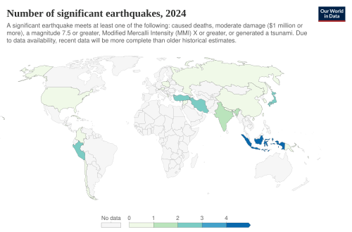
- 発生頻度: 1900年以降、年平均でM7.0〜7.9の主要地震が18回、M8.0以上の巨大地震が1回発生しています。
地震が発生する仕組みと断層の役割
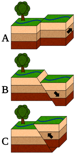
地震の多くは、岩盤の割れ目である断層が急激にずれることで発生します。断層の動き方によって、大きく分けて3つのタイプに分類されます。地盤が引っ張られてずれる「正断層」、押し込まれてずれる「逆断層」、そして水平方向にすれ違う「横ずれ断層」です。
特にプレートが沈み込む境界で発生する「メガスラスト地震」は、破壊される断層面積が非常に広いため、世界最大級の規模になります。断層の幅が広いほど、蓄積されるエネルギー量が増え、結果としてマグニチュードが大きくなる傾向にあります。
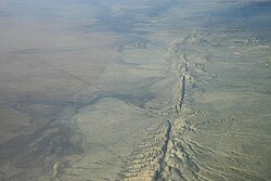
また、火山活動に伴う地震や、人間活動(流体注入など)によって誘発される「誘発地震」も存在します。さらに、明確な本震がなく、似た規模の地震が短期間に連続して発生する「群発地震」という現象も見られます。
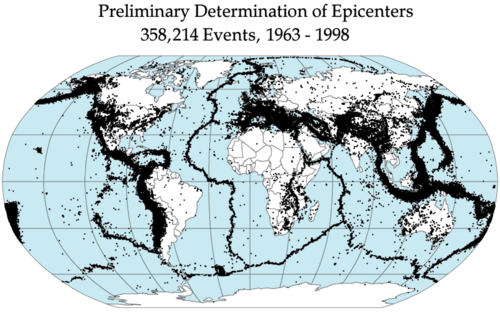
地震の規模と強さを測る指標
地震の大きさを表すには、エネルギー量を示す「マグニチュード(規模)」と、ある地点での揺れの強さを示す「震度(強度)」の2つの概念が使い分けられます。
マグニチュードの特性
初期のリヒター scale から始まり、現在は断層の破壊面積や岩盤の剛性を考慮した「モーメントマグニチュード」が主流です。マグニチュードの数値がわずかに上昇しても、実際のエネルギー量は飛躍的に増大します。例えば、M7.0の地震はM5.0の約1,000倍のエネルギーを放出します。
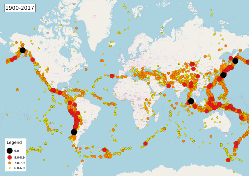
震度と体感的な揺れ
震度は、気象庁震度階級やメルカリ震度階級のように、建物への影響や人間の感覚に基づいた指標です。同じ地震であっても、震源からの距離や地盤の kondisi によって、場所ごとに異なる震度が観測されます。
![Earthquakes of magnitude 8.0 and greater from 1900 to 2018. The apparent 3D volumes of the bubbles are linearly proportional to their respective fatalities.[1]](/images/5f/d3/5fd3b6a08eb995ae5ab2ecae3df3197472497469613d56e32c1e1ab9c37e3004.webp)
地震波の伝播と観測
地震が発生すると、震源(ハイポセンター)から地震波が球状に広がります。地震波には主に以下の3種類があります。
- P波(縦波): 最も速度が速く、最初に到達する圧力波です。
- S波(横波): P波より遅く、大きな揺れをもたらす波です。
- 表面波(レイリー波・ラブ波): 地表付近を伝わり、特に長周期の揺れを引き起こします。
これらの波の到達時間の差を利用することで、震源地(エピセンター)の特定や、地球内部の構造解析が可能になります。波の速度は媒体の密度や弾性に依存し、深いマントルほど速く伝わります。
地震がもたらす複合的な災害
地震の被害は、単なる建物の倒壊にとどまりません。地盤の性質や地理的条件により、多様な二次災害が誘発されます。
地盤と構造物への影響
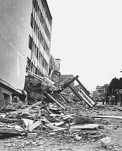
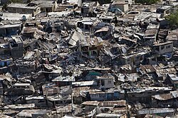
激しい揺れによる建物の崩壊だけでなく、砂地などで水分を含んだ地盤が液体のように振る舞う「液状化現象」が発生することがあります。また、急傾斜地では大規模な地滑りが起こり、多くの犠牲者を出す要因となります。
広域的な二次災害
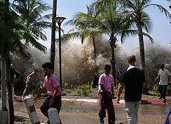
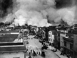
海底で発生した地震は、巨大な津波を引き起こし、沿岸部に壊滅的な打撃を与えます。また、ガス管の破裂や電気配線のショートによる大規模な火災が発生し、揺れ以上の被害を拡大させるケースも少なくありません。
歴史的な大災害の例
過去には、1755年のリスボン地震や1908年のメッシーナ地震など、津波と火災が重なり、数万人規模の犠牲者を出した悲劇が記録されています。近年の2023年トルコ・シリア地震のように、超高速で断層が破壊される「スーパーシア」現象を伴う地震も確認されています。

![The Messina earthquake and tsunami took about 80,000 lives on December 28, 1908, in Sicily and Calabria.[40]](/images/b7/90/b790ff08a9b556b8a2a3696b1d50f7754007e8b40e10e1d4688a5ea9acfc54f1.jpg)
![The 2023 Turkey–Syria earthquakes ruptured along segments of the East Anatolian Fault at supershear speeds; more than 50,000 people died in both countries.[26]](/images/06/5f/065f785b5cb826cbe7a23cb02e86f840c9815123a597afc98a79161b5218c43e.jpg)
地震の統計と傾向
現代では観測網が飛躍的に拡大したため、報告される地震数は増えていますが、これは計測精度の向上によるものであり、地震の発生頻度自体が劇的に増加しているわけではありません。
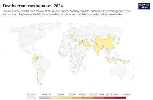
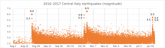
ただし、地質学的なサイクルによって活動が活発な時期があると考えられており、継続的なモニタリングが不可欠です。イタリアでの一連の地震に見られるように、本震の後に続く余震のパターンを分析することは、リスク管理において重要です。
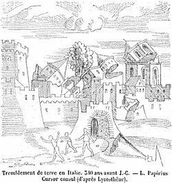
また、古代から地震は人々の記憶に刻まれており、歴史的な記録や芸術作品の中にもその恐怖と教訓が残されています。
地震データのまとめ
| 項目 | 詳細・特徴 | 備考 |
|---|---|---|
| 主要な断層タイプ | 正断層、逆断層、横ずれ断層 | 動き方で分類 |
| エネルギー増幅率 | M+1につき約32倍 | 対数的な増加 |
| 地震波の種類 | P波(速)、S波(中)、表面波(遅) | 速度と性質が異なる |
| 主な二次災害 | 津波、地滑り、液状化、火災 | 複合的に発生 |
| 最大観測規模 | マグニチュード 9.5 | 1960年チリ地震 |
Frequently Asked Questions
地震の回数は本当に増えているのでしょうか?
いいえ、統計的には安定しています。世界中で地震報告が増えたのは、地震計の設置数が増え、小さな揺れまで検知できるようになったためです。
マグニチュードと震度の違いは何ですか?
マグニチュードは地震そのものが持つ「エネルギーの大きさ」を示す絶対的な値です。一方、震度はある特定の場所で「どれだけ揺れたか」を示す相対的な値です。
P波とS波のどちらが危険ですか?
一般的にS波の方が危険です。P波は到達が速いですが揺れは小さく、後から来るS波が大きな横揺れをもたらし、建物に大きなダメージを与えます。
地震予知は完全に可能なのですか?
現時点では、特定の時間・場所・規模を正確に言い当てる完全な予知は困難とされています。そのため、確率的な「予測(フォーキャスティング)」と日頃の備えが重要視されています。
なぜ環太平洋地域で地震が多いのですか?
この地域は多くのプレートの境界が集中しており、プレートの沈み込みや衝突が頻繁に起こるため、エネルギーが蓄積しやすく地震が発生しやすいためです。
References
- "USGS: Magnitude 8 and Greater Earthquakes Since 1900". Archived from the original on April 14, 2016.
- "Earthquakes with 50,000 or More Deaths". United States Geological Survey. Archived from the original on November 1, 2009.
- Spignesi, Stephen J. (2005). Catastrophe!: The 100 Greatest Disasters of All Time.
- "Cool Earthquake Facts". United States Geological Survey. Archived from the original on 2021-04-20. Retrieved 2021-04-21.
- Pressler, Margaret Webb (14 April 2010). "More earthquakes than usual? Not really". KidsPost. The Washington Post. pp. C10.
- Kanamori Hiroo. "The Energy Release in Great Earthquakes" (PDF). Journal of Geophysical Research. Archived from the original (PDF) on 2010-07-23. Retrieved 2010-10-10.
- "How Much Bigger?". United States Geological Survey. Archived from the original on 2011-06-07. Retrieved 2010-10-10.
- Ohnaka, M. (2013). The Physics of Rock Failure and Earthquakes. Cambridge University Press. p. 148. .
- Vassiliou, Marius; Kanamori, Hiroo (1982). "The Energy Release in Earthquakes". Bull. Seismol. Soc. Am. 72: 371–387.
- Spence, William; S.A. Sipkin; G.L. Choy (1989). "Measuring the Size of an Earthquake". United States Geological Survey. Archived from the original on 2009-09-01. Retrieved 2006-11-03.
📸 フォトギャラリー