地球の表面積の約32%を占める太平洋は、単なる巨大な水塊ではなく、地球の気候、地質、そして人類の歴史に決定的な影響を与えてきた世界最大の海洋です。その面積は1億6,525万平方キロメートルに及び、地球上の全陸地を合わせた面積よりも広大であるという驚くべき特徴を持っています。
北極圏から南極圏まで広がるこの海は、赤道を境に北太平洋と南太平洋に分かれ、さらに日付変更線によって東太平洋と西太平洋に区分されます。この広大な水域は、アジアとオーストラリアをアメリカ大陸から隔てる重要な地理的境界となっています。
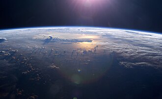
Key Facts
- 最大面積:地球の全水面の約46%をカバーし、全陸地面積を上回る。
- 最深点:マリアナ海溝のチャレンジャー海淵(水深10,911m)。
- 地質的変動:プレートテクトニクスにより、年間約2.5cmずつ縮小している。
- 気候への影響:エルニーニョ・南方振動(ENSO)が世界的な気象パターンを左右する。
- 環境課題:巨大なプラスチックごみ集積帯(グレート・パシフィック・ガベージ・パッチ)が存在する。
太平洋の地理と物理的特性
太平洋の平均水深は約4,280メートルに達し、地球上で最も深い地点が集中しています。特に北西太平洋に位置するマリアナ海溝は、世界最深部として知られています。また、南半球最深点であるトンガ海溝のホライゾン海淵もこの海域に存在します。
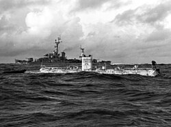
海水の特性は緯度によって大きく異なります。赤道付近では豊富な降水により塩分濃度が低くなる傾向にありますが、南東部では最大37‰(パーミル)に達します。また、水温は極圏の氷点下から赤道付近の約30℃まで幅広く分布しています。海流は北半球では時計回り(北太平洋亜熱帯循環)、南半球では反時計回りに流れており、黒潮などの暖流が気候に大きな影響を与えています。
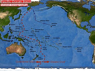
島嶼部の構成
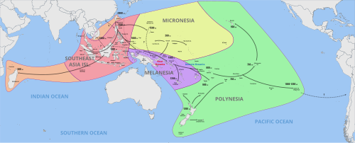
太平洋には数多くの島々が点在しており、文化・地理的に大きくミクロネシア、メラネシア、ポリネシアの3つの地域に分類されます。これらの島々は、火山活動やサンゴ礁の形成によって誕生しました。
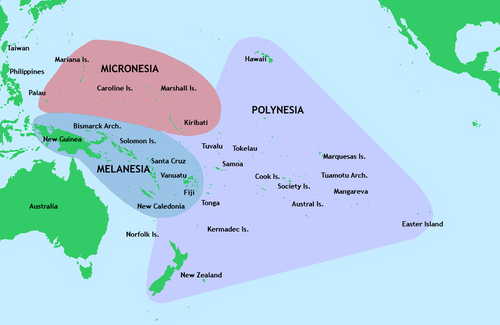
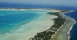
特に環礁(アトール)と呼ばれる環状のサンゴ礁島は、キリバスのタラワ環礁などに代表される太平洋特有の景観を作り出しています。
地質学的ダイナミズム:環太平洋火山帯
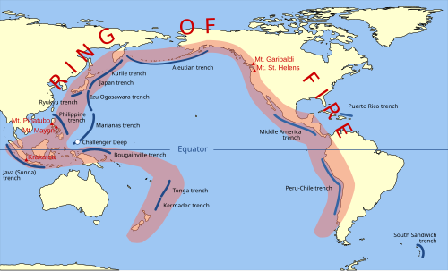
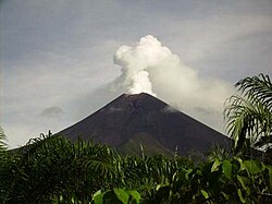
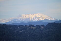
太平洋の周囲は、多くの火山や海溝が連なる環太平洋火山帯(リング・オブ・ファイア)に囲まれています。これはプレートの沈み込み帯に沿って地震や火山噴火が頻発するためです。アメリカのセントヘレンズ山やパプアニューギニアのウルアウン山などの成層火山がその象徴と言えます。
人類の移動と探検の歴史
先史時代の航海
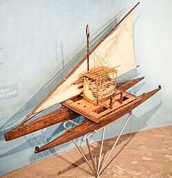
人類の太平洋進出は極めて古く、約6万〜7万年前の旧石器時代に、アフリカを出発した人々が東アジアを経てニューギニアやオーストラリアに到達したと考えられています。その後、優れた航海術を持つオーストロネシア系の人々が、ダブルカヌー(双胴船)などの船舶を用いて、広大なポリネシア地域へと広がっていきました。
ヨーロッパによる探検と帝国主義
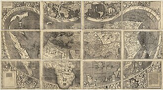
記録に残る最初の太平洋横断は、1520年のフェルディナンド・マゼランによるものです。彼は航海中に穏やかな海面に遭遇したため、この海を「パシフィコ(平和な)」と名付けました。その後、スペインやポルトガルの探検隊がアジアや日本へと到達し、世界地図が書き換えられていきました。
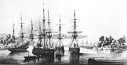
19世紀に入ると、フランス、イギリス、アメリカ、ドイツ、日本などの列強による帝国主義的な領土拡大が進み、タヒチやニューカレドニアなどの島々が保護領や植民地となりました。
現代の環境問題と経済
太平洋は現在、深刻な環境汚染に直面しています。特に日本や中国などの人口密集地に近い北西太平洋では、マイクロプラスチック汚染が顕著です。カリフォルニア沖から日本にかけて形成された「太平洋ごみベルト」は、フランスの3倍もの面積に達すると推定されています。
![Pacific Ocean currents have created three islands of debris.[100]](/images/af/78/af78a3e19f5a6e96c06d76d054e770617db144c7136171e5d967b861c4d6d079.jpg)
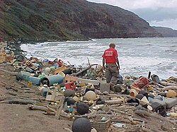
また、核実験による影響や、福島第一原子力発電所からの処理水の放出といった放射性物質の問題も、国際的な議論の対象となっています。
![In 2020, Japanese Prime Minister Suga declined to drink the bottle of Fukushima's treated radioactive water that he was holding, which would otherwise be discharged to the Pacific.[107]](/images/5f/e8/5fe8e604ef2b3bda7758c205d253fb579718e6100ae1f73922e3923e5fb6756f.jpg)
気候変動と経済的影響
太平洋の海面温度の変化は、エルニーニョやラニーニャ現象を引き起こし、北米を含む世界各地の天候に劇的な影響を及ぼします。また、排他的経済水域(EEZ)の設定により、漁業資源の管理や深海採掘などの経済活動が重要な課題となっています。
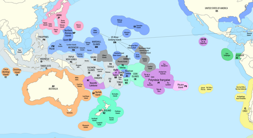
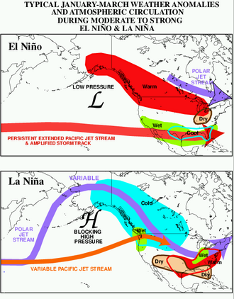
さらに、台風(タイフーン)などの強力な熱帯低気圧が発生しやすく、1979年の台風チップのような記録的な猛威を振るうこともあります。

太平洋の基本データまとめ
| 項目 | 数値・詳細 |
|---|---|
| 表面積 | 約165,250,000 km² |
| 平均水深 | 4,280 m |
| 最大水深 | 10,911 m(マリアナ海溝) |
| 総水量 | 約7億1,000万 km³ |
| 地球表面に占める割合 | 約32% |
Frequently Asked Questions
太平洋という名前の由来は何ですか?
16世紀の探検家フェルディナンド・マゼランが、激しい嵐の海を抜けた後に非常に穏やかな海面に遭遇したため、ラテン語で「平和な」を意味する「パシフィコ(Pacífico)」と名付けたことに由来します。
世界で最も深い場所はどこにありますか?
北西太平洋のマリアナ海溝にある「チャレンジャー海淵」が世界最深点であり、水深は約10,911メートルに達します。
太平洋は大きくなっているのか、小さくなっているのか?
プレートテクトニクスの影響により、太平洋は3つの側面で年間約2.5センチメートルずつ縮小しています。対照的に、大西洋は拡大傾向にあります。
「太平洋ごみベルト」とは何ですか?
北太平洋の海流(環流)によって、プラスチックごみが集積してできた巨大なごみ帯のことです。その面積はフランスの約3倍に及び、海洋生態系に深刻な影響を与えています。
エルニーニョ現象とはどのような現象ですか?
太平洋赤道域の海面水温が通常より高くなる現象です。これにより大気循環が変化し、北米や南米、そしてアジアを含む世界各地で異常気象や干ばつ、豪雨などの気候変動が引き起こされます。
References
- "Pacific Ocean". . 2008: Encyclopædia Britannica, Inc.
- "The Coriolis Effect". National Oceanic and Atmospheric Administration. Retrieved 8 April 2022.
- "How big is the Pacific Ocean?". US Department of Commerce, National Oceanic and Atmospheric Administration. Retrieved 18 October 2018.
- "Deepest Submarine Dive in History, Five Deeps Expedition Conquers Challenger Deep" (PDF).
- "CONFIRMED: Horizon Deep Second Deepest Point on the Planet" (PDF).
-
 One or more of the preceding sentences incorporates text from a publication now in the : Herbermann, Charles, ed. (1913). "Ferdinand Magellan". . New York: Robert Appleton Company.
 - Andrews, Evan (17 October 2023). "10 Surprising Facts About Magellan's Circumnavigation of the Globe". history.com. . Retrieved 27 September 2024.
- O'Connor, Sue; Hiscock, Peter (2018). "The Peopling of Sahul and Near Oceania". In Cochrane, Ethan E; Hunt, Terry L. (eds.). The Oxford handbook of prehistoric Oceania. New York: Oxford University Press. .
- Jett, Stephen C. (2017). Ancient Ocean Crossings: Reconsidering the Case for Contacts with the Pre-Columbian Americas. University of Alabama Press. pp. 168–171. . Archived from the original on 26 July 2020. Retrieved 4 June 2020.
- Mahdi, Waruno (2017). "Pre-Austronesian Origins of Seafaring in Insular Southeast Asia". In Acri, Andrea; Blench, Roger; Landmann, Alexandra (eds.). Spirits and Ships: Cultural Transfers in Early Monsoon Asia. ISEAS – Yusof Ishak Institute. pp. 325–440. . Archived from the original on 26 July 2020. Retrieved 4 June 2020.
 One or more of the preceding sentences incorporates text from a publication now in the : Herbermann, Charles, ed. (1913). "
📸 フォトギャラリー