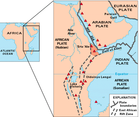
アフリカ大陸の東部に位置する東アフリカ地溝帯(EAR/EARS)は、現在進行形で大陸が引き裂かれている世界的に稀な活動的リフト帯です。約2,200万年から2,500万年前のマイオセン紀に形成が始まったこのシステムは、かつて「グレートリフトバレー」と呼ばれた広大な構造の一部であり、その影響は北は小アジア(アナトリア)まで及んでいます。
この地域では、巨大なアフリカプレートが「ヌビアプレート」と「ソマリアプレート」という2つのプレートに分裂しようとしており、年間8〜9mmという速度で互いに遠ざかっています。また、北部のビクトリアマイクロプレートのように、周囲の地殻構造の影響で反時計回りに回転する小さなプレートも存在し、複雑な地殻変動が起きています。
Key Facts
- プレートの分裂:アフリカプレートがヌビアプレートとソマリアプレートに分断されつつある。
- 形成時期:約2,200万〜2,500万年前から活動が開始。
- 地理的範囲:アファール三角地帯を起点に、紅海、アデン湾、そして南はモザンビーク沖まで延びる。
- 気候への影響:高地の形成や湖の存在が、地域的な降雨パターンやインド洋の季節風に影響を与えている。
- 人類学的な重要性:堆積環境が良好なため、「ルーシー」などの重要な人類祖先の化石が多数発見されている。
地溝帯の構造と広がり
東アフリカ地溝帯は、数千キロメートルにわたる一連のリフト盆地で構成されています。北端のアファール三角地帯(トリプルジャンクション)からは、西の紅海リフトと東のアデン湾リッジへと道が分かれています。
アファールより南側では、主に2つの大きな分岐に分かれます。一つは「東部リフトバレー(グレゴリーリフト)」で、エチオピアからケニアを経てタンザニア北部まで伸びています。もう一つは「西部リフトバレー」で、コンゴ民主共和国、ウガンダ、ルワンダ、ブルンジ、タンザニア、ザンビア、モザンビークを縦断し、マラウイ湖などの大湖群を形成しています。
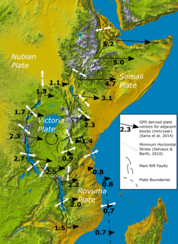
さらにこの構造は海域まで続いており、モザンビーク沖のケリンバ地溝やラセルダ地溝、そして長さ2,200kmに及ぶデイビリッジなどの断裂帯として現れています。
地質学的進化とメカニズムの論争
この地溝帯がどのようにして形成されたかについては、長年議論が続いてきました。かつては地殻密度の差によるものという説がありましたが、1990年代以降は地下深部のマントルプルーム(高温の岩石が上昇する柱状の構造)が関与しているという説が有力視されています。
最新の理論(2009年)では、マグマ活動とプレートテクトニクスが相互に影響し合っていると考えられています。地殻が薄くなることで火山活動が活発になり、そのマグマの貫入がさらに地殻を弱め、薄くするというフィードバックループが起きています。このプロセスが数千万年続けば、東アフリカは最終的に大陸から切り離され、新しい海になる可能性があります。
![Maps of four different depth slices of the Shear-velocity (Vs) model developed by Emry et al. 2018.[15] The forms of the zones with lower Vs (colors toward red) suggest the hotter structures in the Mantle. The distinguishing fourth map depicts a depth below the 410 km discontinuity where Vs steeps up (getting overall bluer), but it still displays the signature of a plume at the substrate of the East African Rift. In the white box, the Vs vertical profile at 10°N, 40°E illustrates the increase of velocity with depth and the effect of the 410 km discontinuity.](/images/62/be/62beba2b9d8894ca5777748ea5a859771e272ceefbf821fef3d3a1a3d6009c86.jpg)
科学的アプローチによる検証
- 同位体地球化学:エチオピアの溶岩分析により、深部マントル由来と大陸リソスフェア由来の複数のプルーム源が存在することが示唆されています。
- 地震波トモグラフィー:地球内部の地震波速度を解析することで、下部マントルから上昇するスーパープルームが上部マントルに小規模なプルームを供給している様子が描き出されています。
- 地球動力学モデリング:3D数値シミュレーションにより、プルームと地殻の相互作用がタンザニアクラトン(非常に古く安定した地殻ブロック)周辺の非対称なリフト形成を再現することに成功しています。
火山活動と地震の特性
地溝帯の形成に伴い、多くの火山が誕生しました。キリマンジャロ山やケニア山などの著名な山々のほか、エチオピアのエルタ・アレのような活動的な火山が存在します。特にタンザニアのオルドイニョ・レンガイは、世界で唯一のナトロカーボナタイト火山であり、シリカをほとんど含まない、オリーブオイルのように低粘度の溶岩を噴出させることで知られています。
地震活動も極めて活発で、特にアファール陥没帯付近で多く発生します。過去100年では最大モーメントマグニチュード7.0に達する地震が記録されており、多くは正断層による浅い震源(12〜15km)の地震です。
環境・気候および人類史への影響
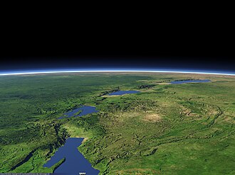
この巨大な地形の変化は、地球の気候にも影響を与えています。エチオピアやケニアの高地は、周囲の乾燥地帯の中で多雨地帯となっており、リフト内に形成された湖(ビクトリア湖など)は水蒸気の供給源として地域気候を左右しています。また、東西に走る谷が風の流れを加速させ、コンゴ盆地の熱帯雨林に大量の雨をもたらす一方で、東アフリカの乾燥化を促進したと考えられています。
さらに、この地溝帯は「人類のゆりかご」とも呼ばれます。急激な浸食と堆積が繰り返される環境であったため、化石が保存されやすく、300万年以上前のアウストラロピテクスである「ルーシー」や、1,000万年前の類人猿(チョロラピテクス、ナカリピテクス)などの重要な発見が相次いでいます。
| 項目 | 詳細・特徴 |
|---|---|
| 主要プレート | ヌビアプレート、ソマリアプレート(分裂中) |
| 主要分岐 | 東部リフト(グレゴリーリフト)、西部リフト(アルベルティネリフト) |
| 代表的な火山 | キリマンジャロ山、エルタ・アレ、オルドイニョ・レンガイ |
| 地質学的特徴 | マントルプルームによる地殻の薄層化、正断層の卓越 |
| 気候的影響 | ソマリジェットの集中、コンゴ盆地への水蒸気輸送 |
Frequently Asked Questions
東アフリカ地溝帯は将来的にどうなりますか?
現在のプレートの動きが続けば、数千万年かけて東アフリカの一部が大陸から完全に分離し、新しい海洋盆地が形成されると考えられています。
なぜこの地域で人類の化石が多く見つかるのですか?
地殻変動による高地の浸食と、谷への急速な堆積というサイクルが繰り返されたため、生物の遺骸が地層に埋もれ、保存されやすい環境が整っていたためです。
オルドイニョ・レンガイ火山が特殊なのはなぜですか?
一般的な火山がシリカ(二酸化ケイ素)を多く含むのに対し、この火山はシリカをほとんど含まないナトロカーボナタイトマグマを噴出するため、溶岩の粘度が極めて低く、化学組成が独特であるためです。
地溝帯の形成は気候にどのような影響を与えましたか?
高地の形成が雨雲を遮ったり、東西に走る谷が風の流れを変えたりすることで、地域的な降雨パターンの変化や、東アフリカの乾燥化、コンゴ盆地の多雨化に寄与しました。
アファール三角地帯とは何ですか?
アラビアプレート、ヌビアプレート、ソマリアプレートの3つのプレートが互いに離れていく「トリプルジャンクション(三重点)」と呼ばれる地点であり、地殻変動が極めて激しいエリアです。
References
- (April 2005). "Continental break-up: The East African perspective". Astronomy and Geophysics. 46 (2): 2.16 – 2.21. :10.1111/j.1468-4004.2005.46216.x.
- Fernandes, R.M.S.; Ambrosius, B.A.C.; Noomen, R.; Bastos, L.; Combrinck, L.; Miranda, J.M.; Spakman, W. (2004). "Angular velocities of Nubia and Somalia from continuous GPS data: implications on present-day relative kinematics". . 222 (1): 197–208. :2004E&PSL.222..197F. :10.1016/j.epsl.2004.02.008.
- Osborne, Hannah (9 June 2020). "One of Africa's Tectonic Plates Is Rotating in a Different Direction to All the Others". .
- GFZ GeoForschungsZentrum Potsdam, Helmholtz Centre (8 June 2020) "Why the Victoria Plate in Africa rotates"
- Corti, G (15 February 2026). "The Ethiopian Rift Valley". National Research Council of Italy, Institute of Geosciences and Earth Resources. Retrieved 16 February 2026.
- Mougenot, D.; Recq, M.; Virlogeux, P.; Lepvrier, C. (June 1986). "Seaward extension of the East African Rift". Nature. 321 (6070): 599–603. :1986Natur.321..599M. :10.1038/321599a0. 4282682.
- Chorowicz, Jean (2005). "The East African rift system". Journal of African Earth Sciences. 43 (1): 379–410. :2005JAfES..43..379C. :10.1016/j.jafrearsci.2005.07.019.
- Mascle, J; Moungenot, D.; Blarez, E.; Marinho, M.; Virlogeux, P. (1987). "African transform continental margins: examples from Guinea, the Ivory Coast and Mozambique". Geological Journal. 2. 22 (S2): 537–561. :1987GeolJ..22S.537M. :10.1002/gj.3350220632.
- Scrutton, R.A. (1978). "Davie fracture zone and the movement of Madagascar". Earth and Planetary Science Letters. 39 (1): 84–88. :1978E&PSL..39...84S. :10.1016/0012-821x(78)90143-7.
- Montelli, R.G.; et al. (2006). "A catalogue of deep mantle plumes: New results from finite-frequency tomography". Geochem. Geophys. Geosyst. 7 (11) 2006GC001248: n/a. :2006GGG.....711007M. :10.1029/2006GC001248.
📸 フォトギャラリー