地球のダイナミックな地質活動において、川の流れが単に地形を削るだけでなく、地殻そのものを押し上げる要因となることがあります。特に造山帯で見られる河川背斜(River Anticline)や、さらに極端な形態であるテクトニック・アニュリズム(Tectonic Aneurysm)は、浸食と地殻の応答が密接に結びついた現象です。本記事では、川の浸食力がどのようにして地殻の構造を変え、深部の岩石を地表へと運ぶのかを詳しく解説します。
Key Facts
- 河川背斜は、大規模な河川による激しい浸食が原因で、川に沿って地殻が局所的に隆起し、凸状の褶曲(背斜)を形成する構造である。
- アイソスタシー(地殻均衡)の原理により、浸食で地表の質量が減少すると、その分だけ下層の地殻が跳ね上がる「リバウンド」が起こる。
- テクトニック・アニュリズムは、極めて弱い地殻と猛烈な浸食力が組み合わさった際、血管瘤(アニュリズム)のように局所的に激しい隆起と岩石の露出が起こる現象である。
- ヒマラヤ山脈のナンガパルバットやナムチェバルワが、このテクトニック・アニュリズムの代表例として知られている。
河川背斜の形成メカニズム
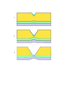
通常、褶曲(しゅうきょく)はプレートの衝突による圧縮力で形成されます。しかし、ヒマラヤのような造山帯では、主要な河川に沿って、圧縮方向とは異なる向きの褶曲が見られることがあります。これが河川背斜です。この構造は、川による深い切り込みと、それに伴う地殻の応答によって生まれます。
鍵となるのはアイソスタシーという概念です。これは、リソスフェア(岩石圏)がアセノスフェア(弱圏)の上に浮いているため、上部の質量が減れば、浮力によって下から押し上げられるという原理です。河川が大量の岩石を削り去ると、その地点の地殻が軽くなり、まるで重しを外した筏(いかだ)のように地殻が跳ね上がります。このプロセスにより、川の両岸に沿って幅50〜80kmに及ぶ緩やかな盛り上がり(背斜)が形成されます。
浸食力と地殻強度の関係
どのような構造が形成されるかは、「河川の浸食力」と「地殻の曲げ剛性(強さ)」のバランスで決まります。地殻が強く、川が小さい場合は「横断背斜」となりますが、地殻が弱く、浸食力が非常に強い大規模な河川では「河川背斜」へと発展します。そして、地殻が極めて脆弱で浸食が極限まで達すると、構造的な「腫れ」のようなテクトニック・アニュリズムへと移行します。
テクトニック・アニュリズム:極限の隆起現象
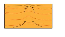
テクトニック・アニュリズムは、局所的な地殻の薄層化と、それに伴う熱的な変化が引き起こす特異な現象です。深い谷が形成されて地殻が薄くなると、上載荷重(上の岩石の重み)が減少するため、その地点の地殻強度が低下します。同時に、地熱勾配が変化し、深部の高温で柔軟な(延性の)岩石が、圧力の低い薄い地殻部分へと吸い寄せられるように流れ込みます。
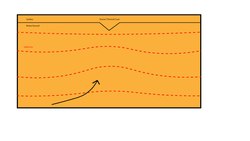
このプロセスでは、深部の岩石が急速に上昇し、減圧融解(圧力が下がることで岩石が溶ける現象)が発生します。これにより熱が地表付近へ効率的に運ばれ、さらに岩石が弱くなるという正のフィードバックが働きます。結果として、周囲よりも遥かに速い速度で深部の岩石が地表に露出(エグズメーション)することになります。
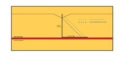
この現象は、地殻の強度プロファイルに顕著に現れます。通常の地殻では深くなるほど圧力で強度が増しますが、激しい浸食がある場所では、上部の質量が失われているため、同じ深さでも周囲より強度が低くなります。
世界各地の事例と観測データ
| 地域 | 主要河川/要因 | 特徴 | |
|---|---|---|---|
| ナンガパルバット(西ヒマラヤ) | インダス川 | 5〜12 mm/年 | 極めて高い比高(谷底から山頂まで約7km) |
| ナムチェバルワ(東ヒマラヤ) | ヤルンツァンポ川 | 約3 mm/年(過去1千万年) | 円形状の隆起域と減圧融解の痕跡 |
| セントエライアス山脈(アラスカ) | 氷河浸食 | 約1.3 mm/年(直近1百万年) | 氷河による浸食が主因。学説に議論がある |
分析手法:岩石の「時計」で速度を測る
地質学者は、鉱物の冷却年齢を測定することで、岩石がどれほどの速さで深部から上昇したかを推定します。例えば、黒雲母(約300℃で閉鎖)とアパタイト(約110℃で閉鎖)の冷却年齢を比較し、その差が小さいほど、岩石が温度勾配を急速に通過した、つまり高速で隆起したことを意味します。また、地震波速度プロファイルを用いて、部分溶融した高温岩石の存在(低速度域)を特定し、熱的な異常を調査します。
Frequently Asked Questions
河川背斜と普通の背斜は何が違うのですか?
普通の背斜は主にプレートの衝突などの水平方向の圧縮力で形成されますが、河川背斜は河川による激しい浸食で地殻が軽くなり、アイソスタシーによって垂直方向に跳ね上がることで形成される点が異なります。
テクトニック・アニュリズムはなぜ「アニュリズム(瘤)」と呼ばれるのですか?
血管の壁が弱くなって局所的に膨らむ「動脈瘤(アニュリズム)」に似ているためです。地殻の強度が局所的に低下し、そこへ深部の物質が集中して盛り上がる様子が、生物学的な瘤の形成プロセスに似ています。
浸食が激しいと、なぜ山が高くなるのですか?
直感的には削られて低くなるはずですが、地殻の質量が失われることで、地球内部からの浮力(アイソスタシー)が働き、下から新しい岩石が押し上げられます。浸食速度が隆起速度を上回ることで、結果的に深部の岩石が地表に現れ、急峻な地形が維持されます。
アラスカの事例では、川ではなく氷河が役割を果たしているのですか?
はい。セントエライアス山脈では、河川の代わりに巨大な氷河による浸食が地殻の質量を削り取り、テクトニック・アニュリズムのような現象を引き起こしたと考えられています。ただし、この説については研究者の間で議論が続いています。
References
- Montgomery, David R.; Stolar, Drew B. (1 December 2006). "Reconsidering Himalayan river anticlines". Geomorphology. 82 (1–2): 4–15. :2006Geomo..82....4M. :10.1016/j.geomorph.2005.08.021.
- Marshak, Ben A. van der Pluijm, Stephan (2004). Earth Structure: An Introduction to Structural Geology and Tectonics (2nd ed.). New York: Norton. pp. 353–354. .
{{}}: CS1 maint: multiple names: authors list () - Robl, Jörg; Stüwe, Kurt; Hergarten, Stefan (20 June 2008). "Channel profiles around Himalayan river anticlines: Constraints on their formation from digital elevation model analysis". Tectonics. 27 (3): n/a. :2008Tecto..27.3010R. :10.1029/2007TC002215. 128173759.
- Simpson, Guy (1 January 2004). "Role of river incision in enhancing deformation". Geology. 32 (4): 341. :2004Geo....32..341S. :10.1130/G20190.2.
- Zeitler, Peter K.; Anne S. Meltz (January 2001). "Erosion, Himalayan geodynamics, and the geomorphology of metamorphism". GSA Today. 11: 4–9. :10.1130/1052-5173(2001)011<0004:EHGATG>2.0.CO;2.
- Burbank; McLean, Bullen; Abdrakhmatov, Miller (1 March 1999). "Partitioning of intermontane basins by thrust-related folding, Tien Shan, Kyrgyzstan". Basin Research. 11 (1): 75–92. :1999BasR...11...75B. :10.1046/j.1365-2117.1999.00086.x. 18460167.
- England, Phillip; Peter Molnar (December 1990). "Surface uplift, uplift of rocks, and Exhumation of rocks". Geology. 18 (12): 1173–1177. :1990Geo....18.1173E. :10.1130/0091-7613(1990)018<1173:SUUORA>2.3.CO;2.
- Lavé, J.; Avouac, J. P. (1 January 2001). "Fluvial incision and tectonic uplift across the Himalayas of central Nepal" (PDF). Journal of Geophysical Research. 106 (B11): 26561–26591. :2001JGR...10626561L. :10.1029/2001JB000359.
- Zeitler, P.K.; Peter O. Koons; Michael P. Bishop (October 2001). "Crustal reworking at Nanga Parbat, Pakistan: metamorphic consequences of thermo-mechanical coupling facilitated by erosion". Tectonics. 5. 20 (5): 712–728. :2001Tecto..20..712Z. :10.1029/2000TC001243.
- Ding, Lin; Zhong, Dalai; Yin, An; Kapp, Paul; Harrison, T. Mark (1 October 2001). "Cenozoic structural and metamorphic evolution of the eastern Himalayan syntaxis (Namche Barwa)". Earth and Planetary Science Letters. 192 (3): 423–438. :2001E&PSL.192..423D. :10.1016/S0012-821X(01)00463-0.
📸 フォトギャラリー